


Autopedestres : Hosingen

Visit Luxembourg
Randonnées de Visit Luxembourg. GUIDE+
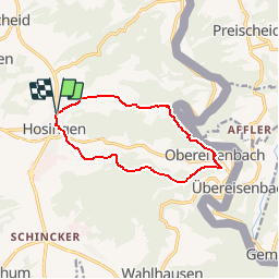

Length
9.9 km

Max alt
529 m

Uphill gradient
309 m
Km-Effort
14 km

Min alt
265 m

Downhill gradient
310 m
Boucle
Yes
Creation date :
2014-12-10 00:00:00.0
Updated on :
2014-12-10 00:00:00.0
--
Difficulty : Unknown

FREE GPS app for hiking
 SityTrail
IGN / Geographical institutes
SityTrail Plus
The world is yours!
About
Trail Walking of 9.9 km to be discovered at Unknown, Canton Clervaux, Parc Hosingen. This trail is proposed by Visit Luxembourg.


Positioning
Country:
Luxembourg
Region :
Unknown
Department/Province :
Canton Clervaux
Municipality :
Parc Hosingen
Location:
Unknown
Start:(Dec)
Start:(UTM)
291681 ; 5544594 (32U) N.
Comments
parcours vallonné et varié, difficulté moyenne.
a tester